

GTN 635H
Fly LPVs With GPS and Talk on VHF
- Touchscreen GPS/Comm backed by decades of proven technology
- Fly WAAS/SBAS LPV approaches down to 200 foot minimums while displaying charts, traffic, weather and more
- Approved for installation in hundreds of makes/models of aircraft around the world
- Interfaces with popular avionics using industry standard protocols
- Cockpit connectivity via Connext™ keeps your tablets and Garmin portables in sync as well as connected with those on the ground
Description
Fly LPVs With GPS and Talk on VHF
- Touchscreen GPS/Comm backed by decades of proven technology
- Fly WAAS/SBAS LPV approaches down to 200 foot minimums while displaying charts, traffic, weather and more
- Approved for installation in hundreds of makes/models of aircraft around the world
- Interfaces with popular avionics using industry standard protocols
- Cockpit connectivity via Connext™ keeps your tablets and Garmin portables in sync as well as connected with those on the ground
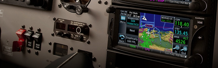
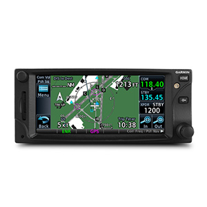
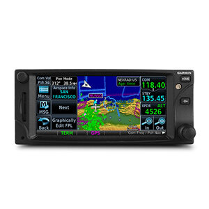
The 2.64-inch GTN 635 puts high resolution terrain mapping, graphical flight planning, multiple weather options, connectivity, advanced navigation, traffic display and much more right at your fingertips. And it’s ready and approved for installation today in hundreds of makes and models aircraft, including helicopters by the U.S.’ FAA, Europe’s EASA, Canada’s TCCA and Brazil’s ANAC authorities.
Touch and Go
With its revolutionary touchscreen interface, GTN 635 puts primary functions just a few taps away. Pan across the map screen by swiping your finger across the 4.9-inch high-resolution TFT display, and enter waypoint data with the onscreen alphanumeric entry.
There are multiple ways to reach information and lots of shortcuts built right in. The data displayed can easily be customized to instantly reach any page in the system right from the moving map or navigation pages — so it’s easy to fly with the information that’s most important to you while flying.
Raised grips in the bezel and a shelf across the lower edge of the display serve as gripping points in both smooth and turbulent flight conditions. Traditional concentric knobs are also available for data input. If you have a GNS 430W/530W, active flight plans automatically crossfill from the GTN to the GNS, or just manually crossfill user waypoints between devices.
Navigate with Ease
Edit your entire route using the map screen and enter new waypoints or modify existing ones, and load Victor and jet airways. A handy “rubber band” feature lets you grab any leg of your flight plan route or direct-to and move it to accommodate a deviation or ATC amendment to your flight plan. Enter your most recently visited or nearest airports as waypoints and “Direct To” destinations.The robust 15-channel GPS receiver generates 5 position updates per second. This SBAS/WAAS-certified technology allows you to fly GPS-guided LPV glidepath instrument approaches down to as low as 200 feet.
For quick access to a second approach attempt without interrupting the flight of the current approach, the GTN allows 2 approaches to be simultaneously loaded. Borrowing advanced navigation from our top-end flight decks provides the ability to create and execute custom holding patterns over an existing waypoint or user-defined waypoint. This same technology simplifies search and rescue operations with selection of 4 common search pattern types for easy entry into the flight plan including, Orbit Search, Parallel Line Search, Expanding Square, and Sector Search pattern types. In addition, precise course deviation and roll steering outputs can be coupled to select autopilots so that IFR flight procedures may be flown automatically. This includes all ARINC 424 leg types, including NextGen radius-to-fix (RF) legs. And when coupled with a G500/G600 Flight Display and compatible autopilot, the aircraft can fly fully coupled missed approaches, including heading legs as well as holds and search and rescue patterns.
Make Communication a Breeze
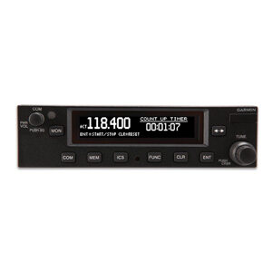
A fully certified, 2,280-channel VHF communications transceiver provides a standard 10 W (or optional 16 W) of power output. The system is pilot-selectable to both 25 kHz and 8.33 kHz channel spacing. Set your standby Com frequency simply by touching the onscreen number pad — it even completes the leading ‘1’ and trailing ‘0’ to help save time. Another touch of the screen switches your active and standby frequencies. And you’ll have added confidence knowing you’re talking to the right controller every time with the automatic display of the station’s identifier right below the frequency, for example KIXD ASOS or CHICAGO ACC. Recent and favorite user frequencies also are a breeze to access. For added safety, holding down the volume knob will automatically dial in the emergency frequency.
See More Than Ever Before
GTN 6d5 brings enhanced situational awareness to your cockpit. With high-resolution terrain mapping — including topography features, cities, airports, terminal areas and SUAs — and optional Class A and B TAWS alerting, you’ll safely find your way around sectional-like airspace depiction, with convenient altitude limits right on the moving map. When interfaced with a compatible fuel computer, a circle is depicted around the aircraft that indicates the estimated distance of travel to reach the aircraft’s fuel reserve and empty fuel conditions. Smart Airspace™ automatically highlights airspace close to your current altitude and de-emphasizes airspace away from the current altitude. The system even allows you to load and follow Victor and jet airways. On the ground, built-in SafeTaxi® airport diagrams give you geo-referenced runways, taxiways, FBOs and hangars available in either the U.S., Europe or Canada.
Add Traffic, Weather and More
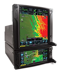
The dual-link GDL® 88 allows the GTN 635 to display up to 60 ADS-B traffic targets. TargetTrend™ relative motion technology offers pilots a faster way to judge the direction and closure rate of intruding targets in relation to their aircraft’s position. TerminalTraffic provides pilots with the most comprehensive picture of ADS-B-equipped aircraft and ground vehicles in the airport environment. ADS-B-equipped aircraft in-flight are easily distinguished from ground vehicles and taxiing aircraft, which are displayed using distinct colors and symbols. All of this information is presented to the pilot on a simple, easy to understand SafeTaxi® diagram with reference to runways, taxiways hangar locations and more. Additionally, when configured for helicopter operations, TerminalTraffic helps pilots easily distinguish potential traffic conflicts while in the airport environment by minimizing nuisance alerts from fixed-wing aircraft and abbreviating select alerts while performing unique helicopter maneuvers such as hovering.
For helicopter use, our exclusive On Scene traffic mode helps pilots prevent continued traffic alerting when they’re aware of other traffic in the vicinity. GDL 88 can also receive the FAA’s subscription-free FIS-B weather broadcasts that include graphical NEXRAD radar information, as well as NOTAMs, METARs and TAFs. GTN gives GDL 88 with the WAAS position source required for ADS-B, so a WAAS version of the GDL 88 is not required. Consider adding a Garmin Traffic System to compliment the GDL 88 to provide the best possible traffic coverage.
Couple the system with a GDL® 69 series datalink receiver to receive XM MX Satellite Weather and SiriusXM Satellite Radio (subscriptions required). An optional GSR 56 provides World Wide Weather data virtually anywhere on the globe, as well as the ability to make and receive phone calls and send and receive texts messages while in the air. To help pilots better understand weather trends, all of the NEXRAD or graphical datalink weather options are animated.
And because the GTN 635 can control the GTX™ 33 remote transponder, a GTN 635 installation could also save you valuable panel space.
Cockpit Connectivity
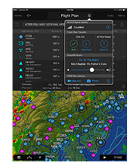
Let our Connext family of products keep your flight plans in sync and stream weather, traffic, GPS, and attitude information to select Connext-capable¹ apps and Garmin portables like Garmin Pilot™ by simply installing a Flight Stream 210. Use the flight plan already created and filed from Garmin Pilot to easily sync to your avionics upon hopping in the cockpit. And once airborne, it’s easier than ever to keep in sync with an ATC amendment — with only a button press or 2 a new route updated on either the GTN or Garmin Pilot without cumbersome re-entry. You’ll also be streaming all of the weather, traffic, GPS and attitude information that your avionics is already providing which makes it easy to cut down on the cockpit clutter of other portable wireless device(s).
Fly with Helicopter-specific Enhancements
 The GTN 635 is available with a number of optional enhancements to help meet the unique demands of helicopter missions. It’s been designed to meet the stringent helicopter vibration and temperature testing standards needed for environmental qualification, and it’s approved for installation in the most popular makes and models helicopters by the U.S.’ FAA, Europe’s EASA, Canada’s TCCA and Brazil’s ANAC authorities. It also features a helicopter-specific obstacle database that adds nearly 30,000 low-altitude obstacles, as well as a navigation database with heliports and high-resolution terrain database.
Remaining aware of where the wires are has never been easier than with Garmin WireAware™, wire-strike avoidance technology. WireAware graphically overlays the most comprehensive powerline information right on the moving map page for the U.S., as well as in some locations in both Canada and Mexico. In addition to its comprehensive coverage, using WireAware adds Hazardous Obstacle Transmission lines that span rivers and canyons and the like, which are particularly dangerous for aircraft. Nobody depicts powerline information quite like the GTN, each segment of the wire can be touched to instantly reveal both MSL and AGL — and they’re also included in the obstacle alerting so they’ll shade either yellow or red given your distance to the lines.
For the ultimate safety solution pair optional HTAWS alerting to provide 5-color shading and audible alerting to show nearby terrain, obstacles and wires in proximity to your helicopter as well as voice callouts when descending below 500 feet. And when you’re in the know of potential hazards, you can use our reduced protection and inhibit modes to help keep alerts to a minimum. When paired with a GRA 55, the GTN can be used to display the altitude and adds HTAWS alerting down to 50 feet.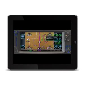
Stay Up-to-date
The GTN 635 features a front-loading SD™ card reader, so you can easily update your databases. Keeping all of your GTN databases in sync has never been easier — simply update 1 GTN and the other downloads the databases automatically, saving valuable time during the update process. Further, database preloading allows pilots to load the next release cycle in advance and activate upon the effective date, making it more convenient to fly with the latest information.
PilotPak™ database bundles are now available on a single aircraft basis, saving you money and simplifying the update process. Visit flyGarmin.com to learn more.
GTN 635 is now available for purchase from your Garmin Authorized Dealer. See it in action at an upcoming seminar or in person at a demo dealer location, or with our free PC Trainer download or iPad® app.
Skye Avionics Services
Design
Certification
Wire Harness
Manufacturing
Sheet Metal
Manufacturing
CNC Machining
3D Printing
Rebuild, Repair & Restore
You can trust the Skye Avionics Team to exceed your expectations.